
Containerized (Docker) deployment
Product installation
Currently, Docker installation supports both Linux X86_64 and Linux ARM architectures. Users need to select the installation package based on the host CPU architecture. Below, we will use the CentOS system on Linux X86_64 as an example to explain the installation and deployment process.
Tip:
Users of containerized installations are required to have administrator privileges, be able to execute sudo, and be in the Docker group. You can create a Docker user group and add installers (such as zondy) to the user group using the following command.
sudo groupadd docker # Create a Docker user group (if it doesn't exist)
sudo usermod -aG docker zondy # Add the current user zondy to the docker group
newgrp docker # Refresh group permissions (or log in directly again)
1. Extract the product package. The product package is a *.zip file and can be extracted using the following command (where mapgis-IGServer-docker-10.7.6.11-x86_64.zip is the downloaded product installation package name; please modify according to your actual situation):
unzip mapgis-IGServer-docker-10.7.6.11-x86_64.zipThe product installation package is a zip compressed package containing the following three parts.
- docker-compose-x86-setup.zip: docker-compose installation package. Users can also download the official installation package to install and configure the device themselves.
- mapgis-igs-$version-x86_64.tar.gz: IGServer Docker Image compressed package。
- mapgis-igs-x86-docker-package.tar.gz: Docker configuration package。
Tip:
Some Linux machines do not have unzip installed. You can first extract it in Windows, then upload the extracted files to Linux.
2. Check whether Docker is installed on the Linux system. If not installed, users need to install manually.
docker --version
3. Check if docker-compose is installed on the Linux system. If not installed, users need to install manually.
docker-compose --version
4. Load the IGServer Docker image file into Docker (where "mapgis-igs-10.7.6.11-x86_64.tar.gz" is the name of the IGServer Docker image compressed file; please modify according to your actual situation):
gunzip -c "mapgis-igs-10.7.6.11-x86_64.tar.gz" | docker loadAfter importing is complete, you can check whether the image file was successfully imported using the following command:
docker images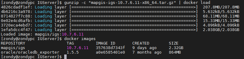
5. Use the following command to extract the configuration file installation package (mapgis-igs-x86-docker-package.tar.gz is the Docker configuration file compressed package; please modify it according to your actual situation):
tar -zxvf mapgis-igs-x86-docker-package.tar.gz6. After successful extraction, you can create a folder called "centos-x86_64" (the folder name may vary slightly depending on the CPU architecture installation package). The files in the folder are as follows:
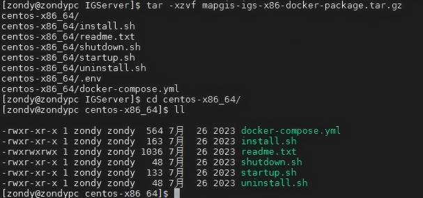
install.sh file must be enforced with executable permissions. Users can set permission information using the following command:
chmod +x install.sh7. Modify the ".env" file in the configuration folder. Users can choose to modify the port information; if not modified, the default 8089 will be used.
vi .env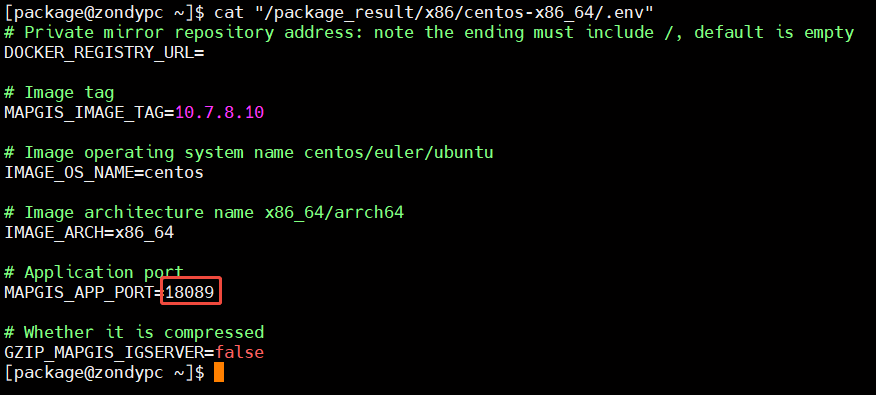
Tip:
1. When multiple IGServer sets are deployed on the host, you must modify the application port number; otherwise, port conflicts may occur.
2、. In some Linux systems, env files are hidden. When connecting to a host via the MobaXterm tool, you can display hidden files by setting them as follows.
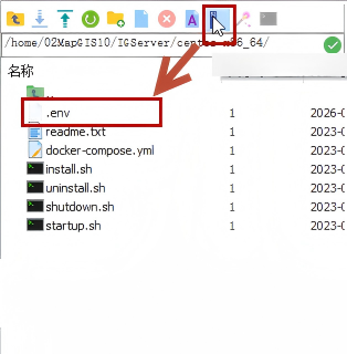
8. View the docker-compose.yml file, where the port and folder hidden relationships between the Docker container and host are configured, allowing users to modify them.
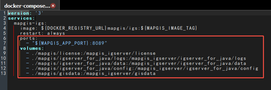
- ports: Configure the mapping port between the Docker container and the host, with the specific format "Host Port: Container Port".
- volumes: Configure the mounting relationship between the folder between the host and the Docker container. The format is "Host Directory: Directory inside the container".
9. Run the installation and startup Docker image script in sequence. After successful execution, a "mapgis" folder will be created in the current directory, which will docker-compose.yml configuration information.
sudo bash install.sh
sudo bash startup.sh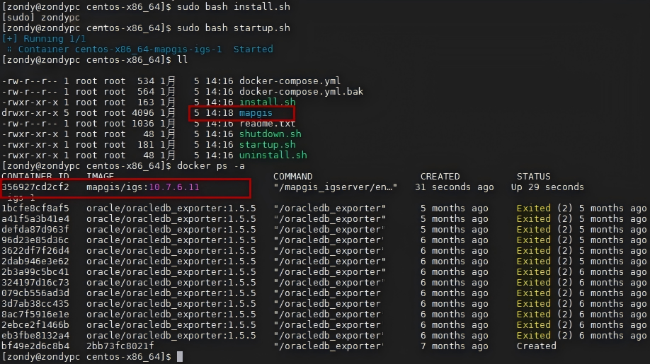
10. If cloud authorization is used, you can place the license file (*.lic) in the "mapgis/license" folder, then execute the closing and starting image script.
sudo bash shutdown.sh
sudo bash startup.sh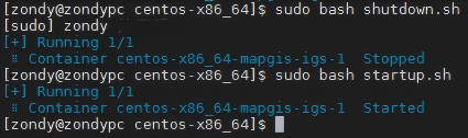
11. Use your browser to access ServerManager (http://IP:port). If the host is networked (accessible to "http://www.smaryun.com/" and "http://www.smarnet.com.cn"), authorization authentication can be performed automatically; If the host is offline and the host is offline, a QR code authentication dialog box will pop up:

12. You can scan the QR code to obtain authentication information via third-party software such as mobile browsers (WeChat is not recommended).

13. After successful authorization and authentication, the IGServer service will automatically restart. After successfully restarting the IGServer service, use your browser to access MapGIS IGServer (JiuZhou) (http://IP:port), enter your username and password to access MapGIS IGServer (JiuZhou).
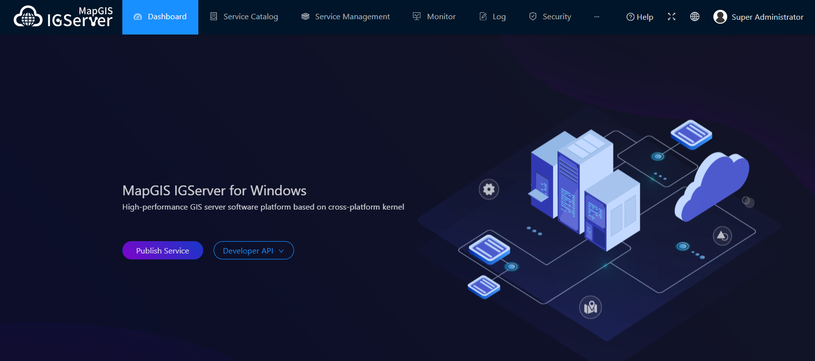
Tip:
The default username is admin, and the password is sa.mapgis.